


Satellite Imagery Data
Access high-resolution satellite imagery data from 195 countries through Techsalerator, covering land use, urban infrastructure, vegetation indices, and water bodies. Ideal for agriculture, real estate, environmental monitoring, and defense industries needing geospatial intelligence and remote sensing data. Explore global coverage options and connect with verified satellite data providers today.
Our Data Integrations
Frequently Asked Questions
What types of data does Techsalerator provide?
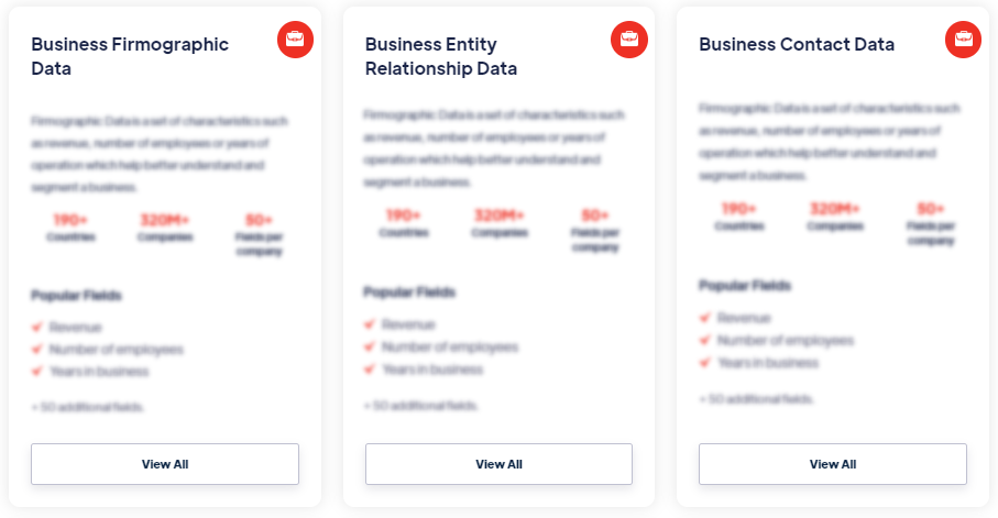
Our datasets cover 195 countries — every major global market — with data sourced locally to maintain accuracy, freshness, and relevance. Coverage varies by category and dataset; specific country coverage is documented on every dataset detail page.
What are the four data pillars?
Our datasets cover 195 countries — every major global market — with data sourced locally to maintain accuracy, freshness, and relevance. Coverage varies by category and dataset; specific country coverage is documented on every dataset detail page.
In which countries is Techsalerator's data available?
Our datasets cover 195 countries — every major global market — with data sourced locally to maintain accuracy, freshness, and relevance. Coverage varies by category and dataset; specific country coverage is documented on every dataset detail page.
How does Techsalerator ensure data quality?
Our datasets cover 195 countries — every major global market — with data sourced locally to maintain accuracy, freshness, and relevance. Coverage varies by category and dataset; specific country coverage is documented on every dataset detail page.
How frequently is the data updated?
Our datasets cover 195 countries — every major global market — with data sourced locally to maintain accuracy, freshness, and relevance. Coverage varies by category and dataset; specific country coverage is documented on every dataset detail page.
What types of data does Techsalerator provide?
Our datasets cover 195 countries — every major global market — with data sourced locally to maintain accuracy, freshness, and relevance. Coverage varies by category and dataset; specific country coverage is documented on every dataset detail page.
What are the four data pillars?
Our datasets cover 195 countries — every major global market — with data sourced locally to maintain accuracy, freshness, and relevance. Coverage varies by category and dataset; specific country coverage is documented on every dataset detail page.
In which countries is Techsalerator's data available?
Our datasets cover 195 countries — every major global market — with data sourced locally to maintain accuracy, freshness, and relevance. Coverage varies by category and dataset; specific country coverage is documented on every dataset detail page.
How does Techsalerator ensure data quality?
Our datasets cover 195 countries — every major global market — with data sourced locally to maintain accuracy, freshness, and relevance. Coverage varies by category and dataset; specific country coverage is documented on every dataset detail page.
How frequently is the data updated?
Our datasets cover 195 countries — every major global market — with data sourced locally to maintain accuracy, freshness, and relevance. Coverage varies by category and dataset; specific country coverage is documented on every dataset detail page.