


Geological Data
Explore comprehensive Geological Data from 195 countries through Techsalerator, covering rock formations, mineral deposits, fault lines, soil composition, stratigraphic layers, and fossil records. Ideal for mining exploration, oil and gas companies, environmental consulting, construction risk assessment, and academic research. Access structured datasets to support geological surveys, hazard mapping, and resource extraction planning worldwide. Request coverage details and pricing today.
Our Data Integrations
Frequently Asked Questions
What types of data does Techsalerator provide?
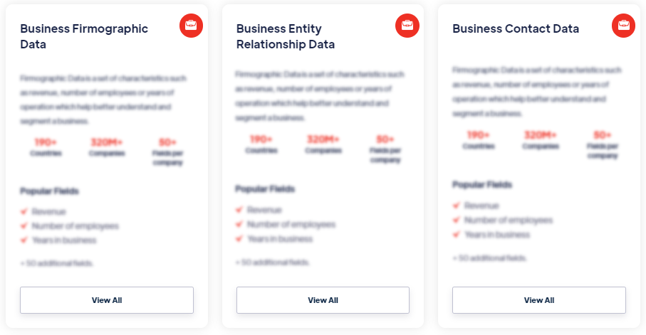
Our datasets cover 195 countries — every major global market — with data sourced locally to maintain accuracy, freshness, and relevance. Coverage varies by category and dataset; specific country coverage is documented on every dataset detail page.
What are the four data pillars?
Our datasets cover 195 countries — every major global market — with data sourced locally to maintain accuracy, freshness, and relevance. Coverage varies by category and dataset; specific country coverage is documented on every dataset detail page.
In which countries is Techsalerator's data available?
Our datasets cover 195 countries — every major global market — with data sourced locally to maintain accuracy, freshness, and relevance. Coverage varies by category and dataset; specific country coverage is documented on every dataset detail page.
How does Techsalerator ensure data quality?
Our datasets cover 195 countries — every major global market — with data sourced locally to maintain accuracy, freshness, and relevance. Coverage varies by category and dataset; specific country coverage is documented on every dataset detail page.
How frequently is the data updated?
Our datasets cover 195 countries — every major global market — with data sourced locally to maintain accuracy, freshness, and relevance. Coverage varies by category and dataset; specific country coverage is documented on every dataset detail page.
What types of data does Techsalerator provide?
Our datasets cover 195 countries — every major global market — with data sourced locally to maintain accuracy, freshness, and relevance. Coverage varies by category and dataset; specific country coverage is documented on every dataset detail page.
What are the four data pillars?
Our datasets cover 195 countries — every major global market — with data sourced locally to maintain accuracy, freshness, and relevance. Coverage varies by category and dataset; specific country coverage is documented on every dataset detail page.
In which countries is Techsalerator's data available?
Our datasets cover 195 countries — every major global market — with data sourced locally to maintain accuracy, freshness, and relevance. Coverage varies by category and dataset; specific country coverage is documented on every dataset detail page.
How does Techsalerator ensure data quality?
Our datasets cover 195 countries — every major global market — with data sourced locally to maintain accuracy, freshness, and relevance. Coverage varies by category and dataset; specific country coverage is documented on every dataset detail page.
How frequently is the data updated?
Our datasets cover 195 countries — every major global market — with data sourced locally to maintain accuracy, freshness, and relevance. Coverage varies by category and dataset; specific country coverage is documented on every dataset detail page.