

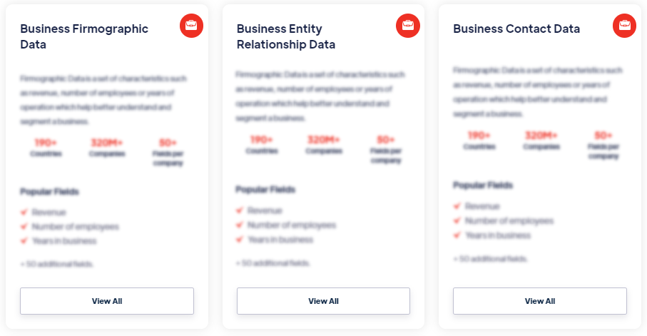


Autonomous Drone Data
Access private Autonomous Drone Data from 195 countries. Includes aerial imagery, GPS telemetry, terrain mapping, and sensor feeds for logistics, agriculture, and surveillance use cases. Get coverage details and pricing from Techsalerator.
Our Data Integrations
Frequently Asked Questions
What types of data does Techsalerator provide?
Our datasets cover 195 countries — every major global market — with data sourced locally to maintain accuracy, freshness, and relevance. Coverage varies by category and dataset; specific country coverage is documented on every dataset detail page.
What are the four data pillars?
Our datasets cover 195 countries — every major global market — with data sourced locally to maintain accuracy, freshness, and relevance. Coverage varies by category and dataset; specific country coverage is documented on every dataset detail page.
In which countries is Techsalerator's data available?
Our datasets cover 195 countries — every major global market — with data sourced locally to maintain accuracy, freshness, and relevance. Coverage varies by category and dataset; specific country coverage is documented on every dataset detail page.
How does Techsalerator ensure data quality?
Our datasets cover 195 countries — every major global market — with data sourced locally to maintain accuracy, freshness, and relevance. Coverage varies by category and dataset; specific country coverage is documented on every dataset detail page.
How frequently is the data updated?
Our datasets cover 195 countries — every major global market — with data sourced locally to maintain accuracy, freshness, and relevance. Coverage varies by category and dataset; specific country coverage is documented on every dataset detail page.